
In the late 1800s Peruvian sailors observed a weather phenomenon in the pacific ocean which occurred around Christmas time. They named it “El Niño” which means little boy in Spanish, referring to Jesus (PBUH) when he was a child. The opposite weather phenomenon was later termed La Niña (little girl).
Today it has become apparent that La Niña and El Niño are normal weather events that appear every 2-7 years. They appear in cycles, which means that we see shifts between La Niña <> neutral phase<> El Niño, and back again, with each phase lasting a few months to a few years. La Niña and El Niño impact both droughts and floods around the entire world. They have partially been blamed as the causes for the Australian wildfires and floods, South Asian (e.g. Indian) floods, Canadian wildfires, and the droughts and floods in East Africa. And it all has to do with the amount of rain.
Why does it rain in Somalia?
In this blog article we describe what controls rainfall in Somalia since this affects both droughts and floods which are are among the main issues in the country. By knowing about the 3 weather phenomena controlling the weather in Somalia, it will be easier to understand and do something about droughts and floods. The 3 phenomena are called:
- 1. La Niña and El Niño
- 2. The Indian Ocean Dipole
- 3. The four yearly rainy and dry seasons
1) Droughts incoming – La Niña in the horizon
At the end of this year (Autumn 2024) there are predictions of a La Niña, which usually leads to droughts in Somalia.
What are La Niña and El Niño? And how do they work?
It all begins in the Pacific Ocean and it’s about wind that pushes ocean water. Normally, the warm winds blow from East (South America) to West (Asia), piling up warm surface water in Asia, Oceania and Australia (see illustration below). This results in the underlying, nutrient-rich, cold water to rise to the surface in the coast of South America, which actually creates good fishing conditions in these regions. This is the normal pattern.
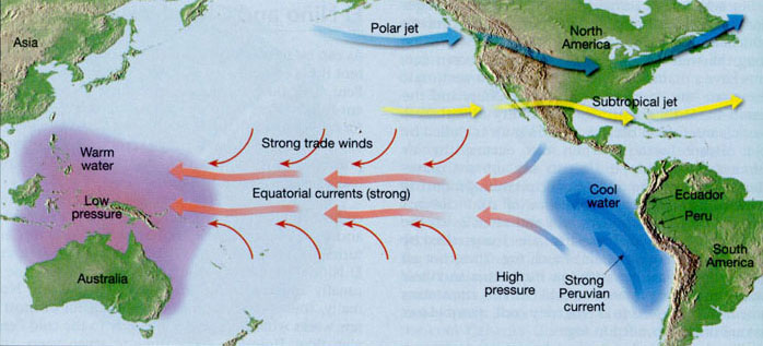
Sometimes, however, these winds become weak and can even blow from West to East (see image below). This means the hot surface water instead piles up in the East Pacific ocean whereby the sea level rises, while it falls in the western part of the ocean (towards Asia) – this is called El Niño and is referred to globally as the warm phase (the reference point being South America – I like to think of Peru since they named the whole phenomena). Despite originating in the pacific, it actually impacts the weather in the whole world including Somalia (e.g. by affecting wind patterns, atmospheric pressures and circulations).
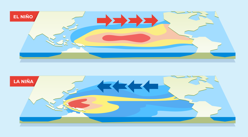
The opposite of El Niño is La Niña – here, the trade winds become stronger than normal and push more hot oceanic surface water towards Asia, allowing for the cold water to rise in the western coast of South America. So, ENSO is simply just variations in the pacific sea surface temperature and the winds. La Niña occurs every 2-7 years, while El Niño occurs every 2-4 years, but the phases are unpredictable.
So how is it measured?
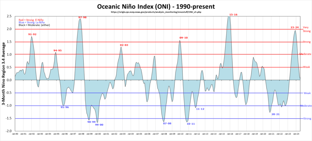
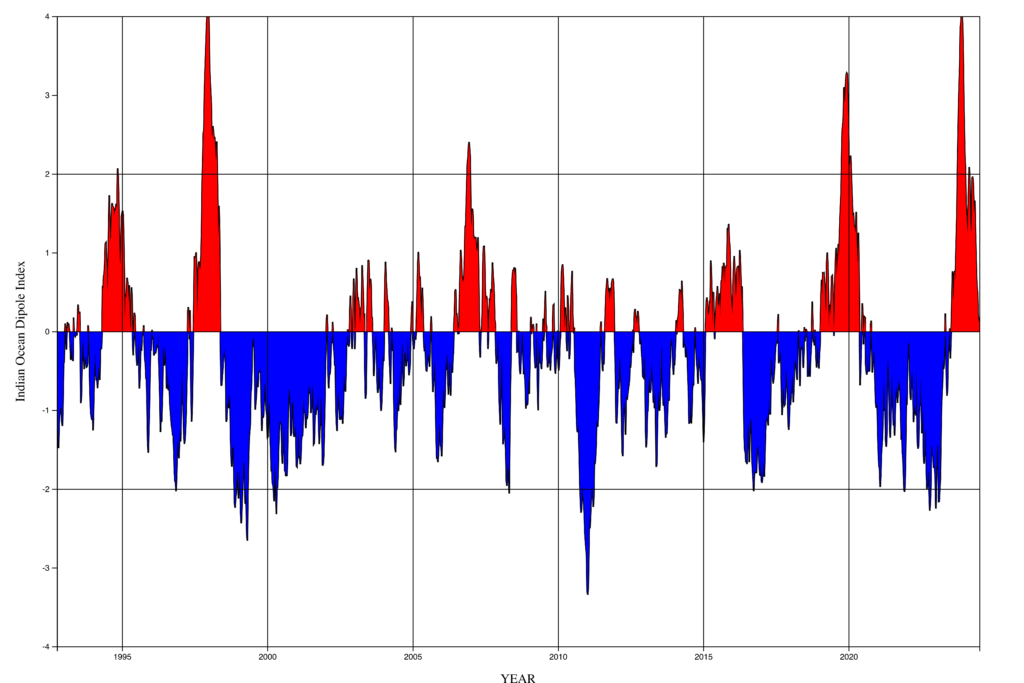
The official name of this entire phenomenon is called El Niño–Southern Oscillation (ENSO) and measured using the “ENSO index” (see the graph below). When it is positive, we have El Niño and when it is negative we have La Niña. Remember that it’s abbreviated “ENSO” as this is how I will refer to it when looking at Somalia’s droughts and floods down below.
In Somalia:
- La Niña = High risk of drought
- El Niño = High risk of flooding
Currently, Somalia (and the rest of the world) have exited a strong El-Niño. Most climate models currently predict that La Niña will begin by October which means there will be less rain in Somalia. Yes, the current neutral phase between the two phases seems to be very short! Less rain will lead to droughts which will reduce crop yields, water accessibility, and if we aren’t prepared eventually death follows in rural areas. During the last drought in Somalia, an excess 43000 deaths could possible be attributed to the drought. We wrote an entire article about the drought in Somalia here, and showed it was the longest drought in centuries. As we consider drought to be among the worst issues in Somalia, understanding why it happens is crucial for coming up with solutions. But ENSO is not the only thing controlling the rainfall in Somalia.
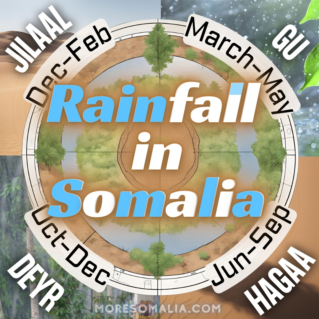
2) The rainy seasons of Somalia
Drought simply means a there is less rainfall which leads to water shortages. The rainfall in Somalia is determined by the rainy seasons – and like many places of the world the yearly seasons can be divided into 4 as depicted below.
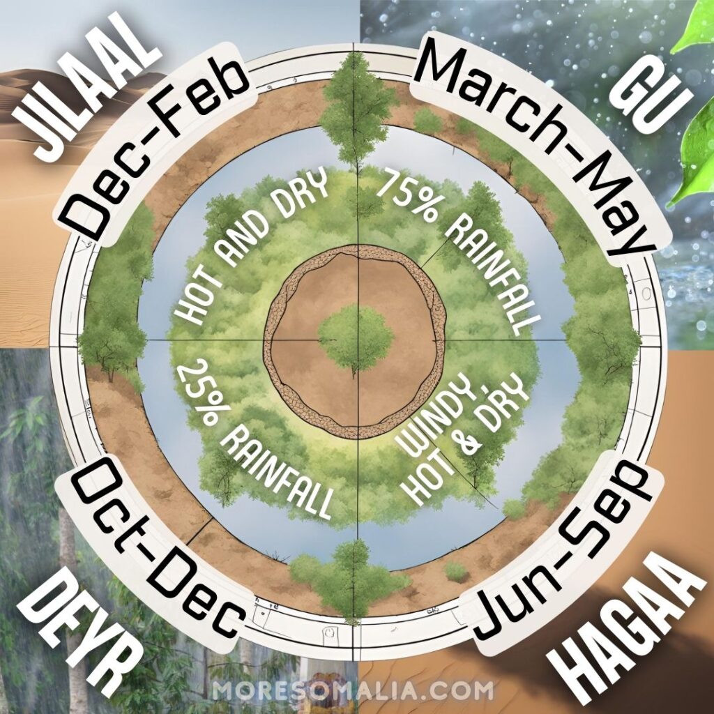
They rainy seasons are:
- “Gu” in March-May responsible for 75% of the yearly rainfall and
- “Deyr” in October-December responsible for 25% of the yearly rainfall.
The reason why Somalia (along with many other countries) have rainy season is called the Intertropical Convergence Zone (ITCZ) – a bit of a mouthful. It basically just means the zone near the equator where the air from both the north and the south comes together and rises up. This zone moves slightly north or south depending on the time of the year. When it passes Somalia in its southward movement we get the Deyr (Autumn) rainy season and when it passes Somalia northwards we get the Gu rainy season. Rain is produced when the ITCZ clouds converge with the moisture from the Indian Ocean (FAO-SWALIM).
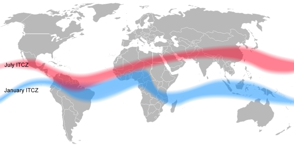
The ITCZ affect the entire weather of Somalia, incl. the wind direction, rain, surface temperature and the evaporation. Together with El Niño/La Niña and the indian ocean dipole it determines how much rainfall will occur in Somalia each season. If you want to go deeper into ITCZ you can watch this video.
3) The Indian ocean dipole
The third and last phenomena is the Indian Ocean Dipole (IOD) – this is very similar to ENSO, but instead of the pacific ocean, it occurs in the Indian ocean at the coast of Somalia. The Indian ocean is the warmest ocean of the five on the planet. Both IOD and ENSO often coincide with each other. The IOD can be in a positive, negative, or neutral phase.
During a positive IOD, the winds push the hot surface water of the Indian Ocean towards the Horn of Africa, where it will accumulates. In the Eastern part ,the colder water will rise towards the surface (this is called upwelling). Once the hot water is accumulated in the coast of Somalia, the warm temperature creates moisture and the air molecules will rise and form clouds which will lead to rainfall. So during a positive IOD, you will see more rain and possibly flooding in Somalia. In South-East asia there will be droughts during this period.
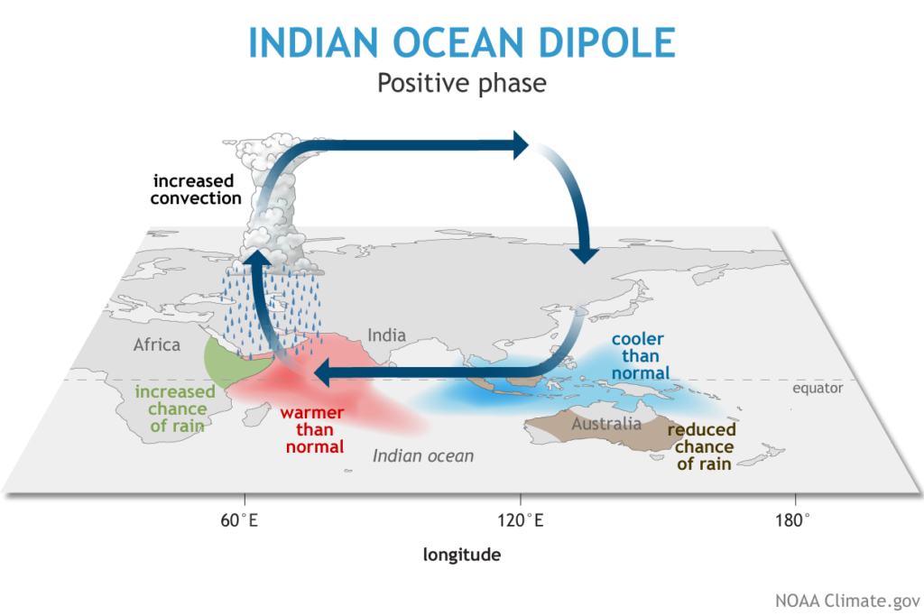
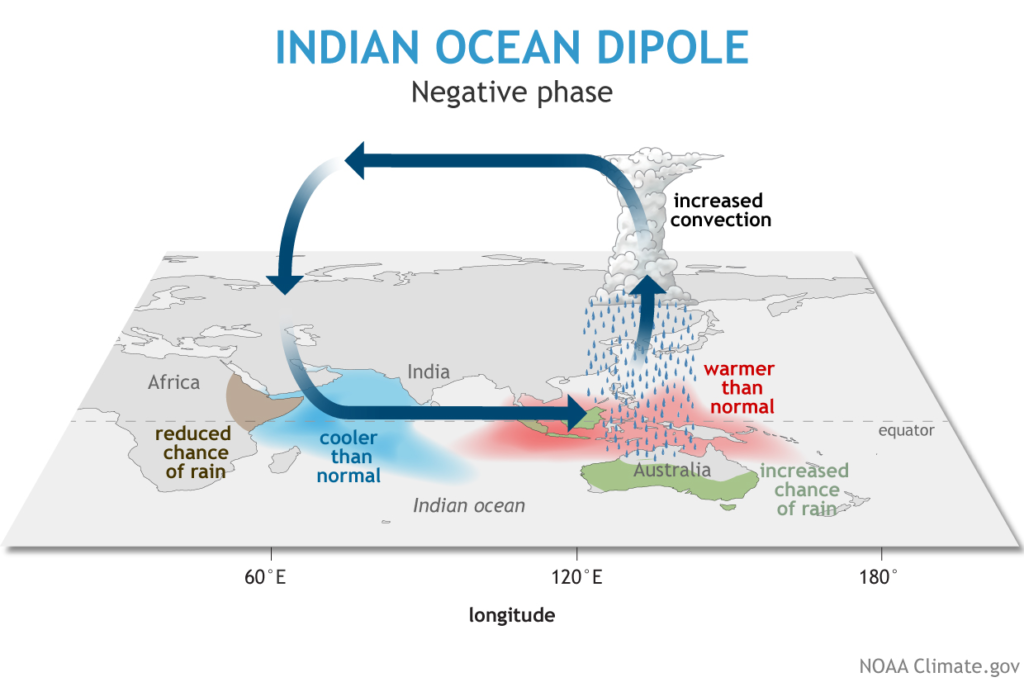
During a positive IOD, the wind pushes the hot surface water in the Indian ocean towards the Horn of Africa where Somalia is. The warm surface water will create a ‘low pressure zone’, the hot air molecules will rise and form clouds at a certain height. These clouds will lead to more rainfall. The opposite of this is a Negative IOD, where there will be drought in the Horn of Africa as the hot surface water will be pushed towards the eastern part of the Indian Ocean.
A negative IOD is the complete opposite. Here a change in the wind pattern causes the hot surface water to be pushed towards the east. The cooler and dry air in East Africa will sink. During this period there will be droughts in Somalia (see the video below for at better explanation).
Why does this happen? The strengthening or weakening of the winds in both directions occur due to seasonal changes, which are driven by the Earth’s axial tilt and the fact that land heats up slower than the ocean.
Rainfall in Somalia
So how much has it actually rained in Somalia? We downloaded the latest rainfall data from CHIRPS and plotted it in this figure below. You can see the monthly rainfall in Somalia for the past 20 years, when the phases of El Niño/La Niña and the IOD phase as well. We have also highlighted when droughts and floods were occuring in Somalia.
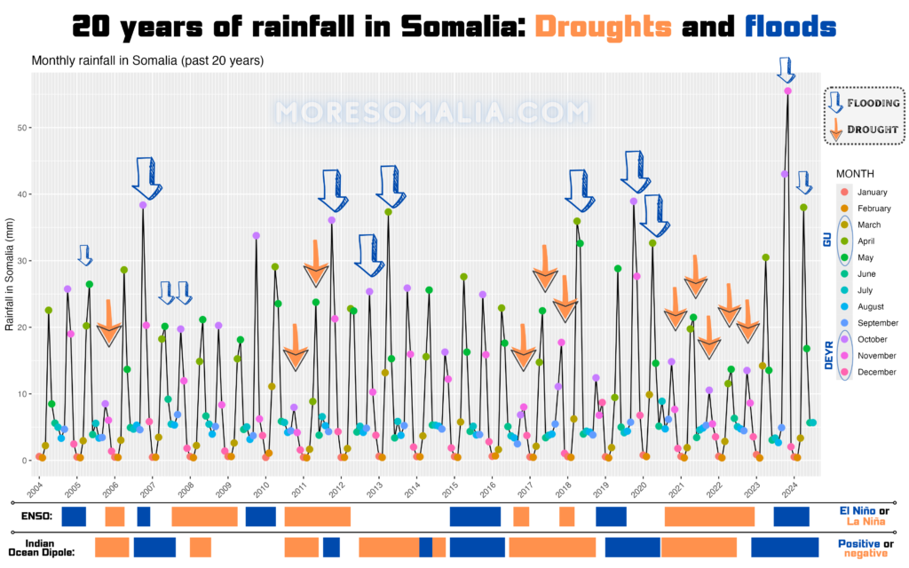
(Data source: CHIRPS rainfall data, IOD from NASA-JPL, ENSO from ggweather, figure created in R studio and Canva)
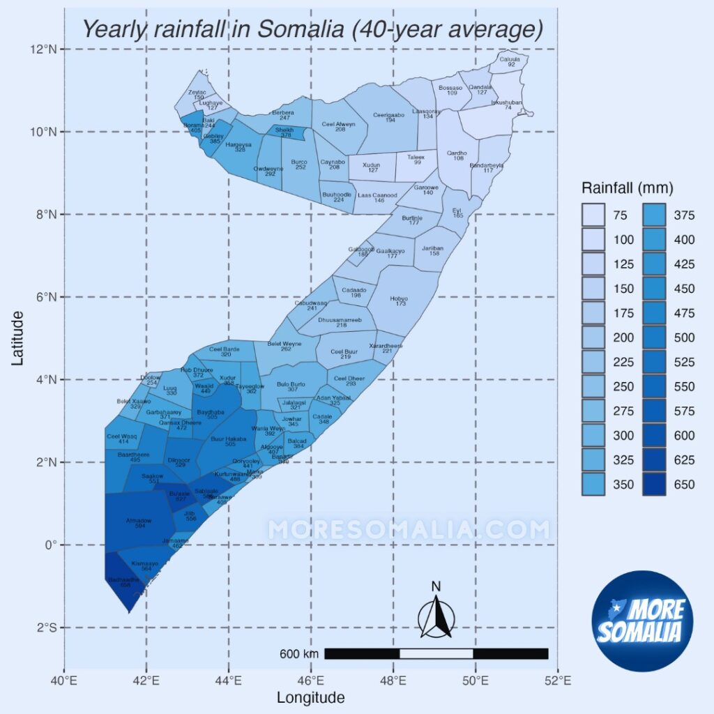
It’s important to know that the rainfall in Somalia is actually very different depending on where you are in the country. The driest parts of the country is the North Eastern part of the Horn, and rainfall will increase the further you move away. In the most southern part of the country, rain will reach over 600 mm per year which is the reason why South Somalia is green whereas The northern part is more dry. Since the southern part can use this rainwater, they also depend more on it, and when it fails they usually experience the consequences of drought more severely. In 2023, the Deyr (autumn) rains were very rough on central Somalia.
What’s the point? Sometimes it rains, sometimes it doesn’t?
Rainfall determines droughts and floods in Somalia – we covered both in our drought article here and flood article here.
The last 3 droughts in Somalia and the following consequences has led to the deaths of over 300,000 Somalis because droughts lead to famine. In addition, the floods both leads to direct deaths but also the displacement of millions of Somalis who have to leave their houses and lives behind.
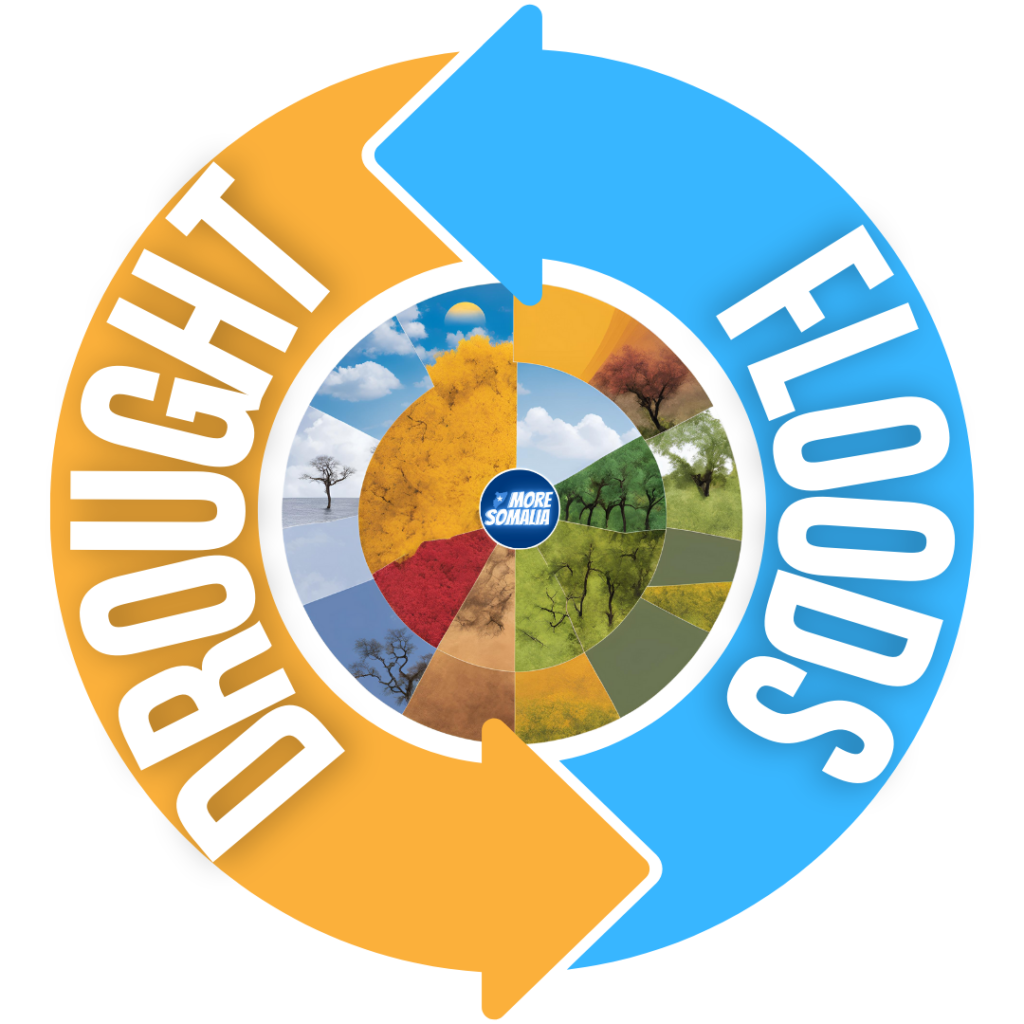
The never ending cycle from droughts to floods and back to droughts, will only be worsened by climate change. But there is still hope.
These issues are environmental but their solutions are political. We know why the weather phenomena occurs, SWALIM is monitoring the rainfall, floods, and environment of Somalia, and we have the engineers to work on the solutions. So how many more deaths does it take for us to work together and find solutions? While the country is obsessed with senseless clan-disputes, nature continues to ravish the country. In addition we are making the problem even worse – evapotranspiration decreases due to the deforestation and charcoal trade in Somalia, which will worsen the droughts.
Somalia is responsible for solving the drought and flood issues inside the country and climate change will only lead to worse El Niños each period.
Conclusion
Now that we know the science behind rain in Somalia, and why droughts and floods occur, the more important question arises – what can we do about it? Are there any smart solutions to the issues?
In part 2, we will dive into some solutions to droughts and floods in Somalia by using examples from other countries. While part 1 is technical/scientific, part 2 will be more solution oriented.

[…] is second part of our drought/flood series. In part 1 we explained the science behind rain in Somalia and how they lead to droughts and floods – […]