
As Somalia is entering the Gu rainy season (March-June), heavy rainfall in East Africa has led to flooding in various parts of the country. Currently Bardhere in the Gedo region is hit hard, but historically beledweyne has been plagued as well. It is not uncommon for floods to happen in the North either. Overall, floods are among the most damaging and frequent disasters on the planet, but we have also gotten better at managing them. Let’s take a look at floods in Somalia.
Two recent reportings from Somali National TV regarding floods:
Why is this happening? And are deaths by floods not preventable in Somalia? As we always here @MoreSomalia, let’s dive a bit deeper into the floods of Somalia.
What are floods?
Let’s first get a clear picture of what we are talking about.
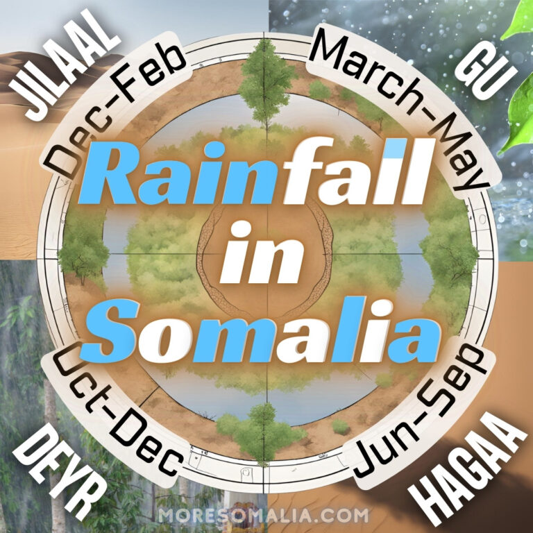
Floods are overflow of water beyond normal limits which submerges land that is usually dry. They are caused due to heavy rainfall or other factors. There are two types of floods: riverine (aka river) and flash. Flash floods happen within six hours and affect localized areas, while riverine flooding are defined as >6 hours and can take months (source). For Somalia:
- Riverine flood = along Jubba and Shabelle rivers in Southern Somalia,
- Flash floods = along intermittent streams in Northern Somalia.
Floods in Somalia and the world
Do you remember the Pakistan flood in October 2022 which claimed the lives of over 1700 people and 40 billion USD in damage and economic loss? Or the 2021 European floods that killed close to 200 people in Germany? Or some of the other major floods that hit Asia during 2021?
Or maybe you have heard about the major floods of Somalia contributing to Somalia’s chronic humanitarian crisis:
| Year, season | Impact |
|---|---|
| 1961, Deyr | Led to the evacuation of thousands. Helicopters provided aid to inaccessible areas with disrupted road communications. Many were displaced. |
| 1977, Deyr | Not enough information |
| 1981, Gu | Evacuation of Beledweyne’s 40,000 population after Somalia’s two main rivers overflowed due to heavy rain in the Ethiopian highlands. The floods devastated refugee camps and agricultural land (more here) |
| 1997, Deyr | At least 2,400 people killed; more than 35,000 livestock killed (more here). Cause: El Niño. Much of it came from runoff from within Somalia and not Ethiopia. |
| 2005, Gu | In Hargeisa, floods destroyed a bridge and damaged homes and electric power lines, affecting over 170 households. Floods struck the Somali region of Ethiopia, washing away 35 villages and causing over 40 fatalities (UNpress) |
| 2006, Deyr | Most damaging flood in East Africa in 50 years; affected at least 300,000 people |
| 2007 | Displaced at least 400,000 people. 3 consecutive seasons of flooding. |
| 2011, Deyr | Displaced at least 1,000 homes (more here) |
| 2012, Deyr | At least 25 people killed; 5,000 livestock drowned; 20,000 people displaced. Beledweyne was hit hard. (more here, and here) |
| 2013, Gu | At least 7 people killed; 50,000 displaced (more here) |
| 2018, Gu | 215,000 people displaced; over 630,000 affected (more here) Cyclone Sagar in Puntland and Somaliland in May: One year of rainfall (200 mm) at once, caused flash floods killing 53 people in Somalia. |
| 2019, Deyr | Over 500,000 people displaced (more her, here and great article from Jamhuriyadda here) |
| 2020 | – East African floods (March-May): Over 500,000 affected; 200,000 displaced; 16 people died. Beledweyne District and Jowhar among the hardest hit regions. Massive flood swept through Qardho. – Cyclone Gati in Puntland (November): Worst cyclone to hit Somalia. 2 times the annual rainfall (100 mm) fell in 2 days. 9 people killed; 10,000 animals killed, millions of dollars in damages. |
| 2023, Gu | Current floods. Over 20 people have died already in Bardhere. |
Droughts > floods > droughts > floods
Below is a figure of the monthly rainfall for all of Somalia in the past 40 years, and the seasons with either droughts or floods in the past 25 years. Click on it to zoom in, especially if you are on the phone!
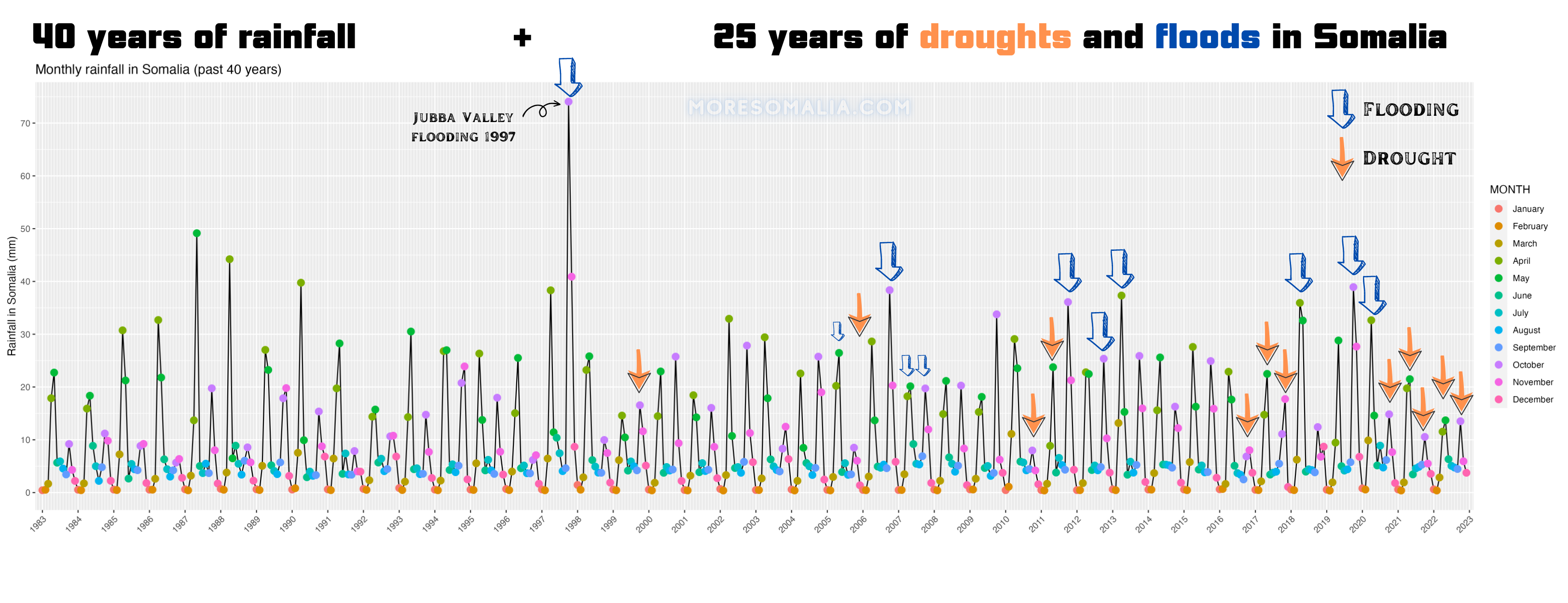
Original figure made in R, illustrations made in Canva. Dataset from CHIRPS.
Droughts used to happen every 5-6 years before 1999, but since then they occur more frequently due to global warming. But it seems that floods always follows these droughts, and since we were just in a 5 season drought (which I believe will not turn into a 6th), more floods are probably coming. But why?
Floods can occur in Somalia after periods of drought because the dry soil cannot absorb the heavy rainfall, resulting in rapid runoff that causes flooding. During droughts, vegetation is scarce and the ground becomes hard and dry, reducing its ability to absorb water. When heavy rainfall does eventually occur, it can quickly lead to flash floods and overflowing rivers (Actalliance). Additionally, during droughts, communities may resort to damaging agricultural and land-use practices such as animal overgrazing and deforestation, which can exacerbate the effects of floods when the rains do come.
In my opinion, the wave of floodings in Somalia will therefore likely be of a severe character, both due to the length of the drought preceding it, and due to the dry soil. The people in the low-lands and near the rivers of Somalia must be prepared to avoid disaster.
Floods are bad, but they can be managed
The Somali flash floods are nothing new:
The Somali Flash Floods occur annually in Somalia due to the Gu and Deyr rains, which bring monsoon-like rainfall every year. These floods affect the Jubba and Shabelle areas during the rainy seasons, causing casualties and displacement. In recent years, the floods have become more severe, potentially due to population growth, lack of preparation, and meteorological/climate reasons.
Problem > Need > Challenge > Solved ✔️:
Efforts to control the effects of the flooding in Somalia have been difficult due to the country’s political instability and economic disparity. In 2007, a new early warning system was suggested to detect floods earlier, but it proved to be costly and difficult to manage successfully. Fortunately, humanitarian aid is often offered to those affected. In May 2013, the United Nations offered a meteorologist position to oversee early warning programs, but it went unfilled due to lack of funding and political restrictions. Today, that warning system has been developed by FAO-SWALIM (see below).
Consequences of the floods
The lack of resilience (meaning capability to withstand and recover fast) in the communities affected by the floods contributes to the devastation caused by the floods. The population suffers from drought, food crises, and diseases as direct results of the massive flooding. The floods cause massive damage to both property and human life, and the communities in the flood areas have little technology to forecast the floods, build adequate housing, or provide transportation away from affected areas.
During floods: people and animals are often stranded on high ground, trees, or bridges. The floods sometimes wash away bridges, houses, and thousands of farm animals. Urgent need for shelter, food, and healthcare services is therefore always created. Floods sometimes render airstrips and roads inaccessible, making it difficult to deliver aid. In addition, waterborne diseases such as cholera become a threat to people’s lives in the short and long term.
Consequences after: loss of crops and livestock, displacement of people from their homes, and damage to homes and property. Farming income and increase in waterborne diseases.
Here’s how bad it went in 1997:
The Jubba and Shabelle valley suffered extensive damage due to the floods, including complete destruction of agricultural crops, land degradation, increased soil erosion leading to silting of irrigation (water for agriculture) barrages, and severe bank erosion of the rivers. Even most of the infrastructure they use to measure was destroyed.
ALL of the settlements along the Jubba River in Somalia were flooded, leading to some villages being completely cut off by the water for extended periods. Along the Shabelle River, numerous villages were submerged for a prolonged period.
Mechanisms of floods
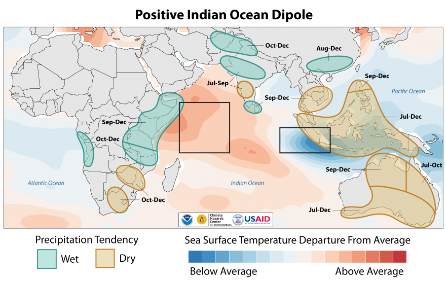
The weather phenomena behind both droughts and floods in Somalia are called La niña and the Indian Ocean dipole (I explained most of it here).
1. A few weeks ago (march 2023), La Niña, which usually leads to drought in Somalia, was declared finished. On the contrary, there is a risk of an El Niño during 2023.
2. The other more important feature was the Indian Ocean Dipole (IOD), which was in a negative phase until recently, contributing to the drought in Somalia. However, this is no more the case, as it is approaching a positive phase. During a positive IOD the indian ocean near East Africa is warm and there is more rain in East Africa.
Last time we entered a positive IOD, it led to flooding and the locust infestation.
3. The Intertropical Convergence Zone (ITCZ) plays a significant role in the flooding events in Somalia too. This is a bit of a mouthful, but it is the reason we have rainy seasons in Somalia. You can watch a video explaining how the ITCZ works here.
The ITCZ is a region near the Equator where the trade winds from the northern and southern hemispheres meet. Its movement throughout the year causes rainfall and dry seasons in East Africa. In Somalia, the ITCZ brings the majority of the country’s rainfall during the Gu (April to June) and Deyr (October to December) seasons. However, if the ITCZ shifts, or if there is a delay in the onset of the rainy season, it can result in drought conditions. And when the rain finally arrives it often comes in intense bursts, leading to floods in the rivers and low-lying areas.
The rivers, floods, and dams
In the Ethiopian highlands originates the water found in the Nile River – the backbone of Egypt’s history, agriculture and existence. The Jubba and Shabelle rivers originates from there as well, and the land surrounding these rivers are known as the breadbasket of Somalia, where you will find crops such as sorghum, maize, onions, tomatoes, and rice. The Ethiopian highlands are sometimes referred to as the roof of Africa with heights between 1500 – 4500 meters.
The water in the Shabelle (“river of leopards”) and Jubba rivers originate from the streams (called tributaries) in the Ethiopian highlands which serve as Catchment areas (aka watershed, drainage basin, river basin, water basin – basically regions of land from which water drains into a river, lake, or reservoir). The two rivers merge during heavy rains before flowing to the Indian Ocean. In dry seasons, access to water becomes difficult for Somalis due to the Shabelle river’s dryness.
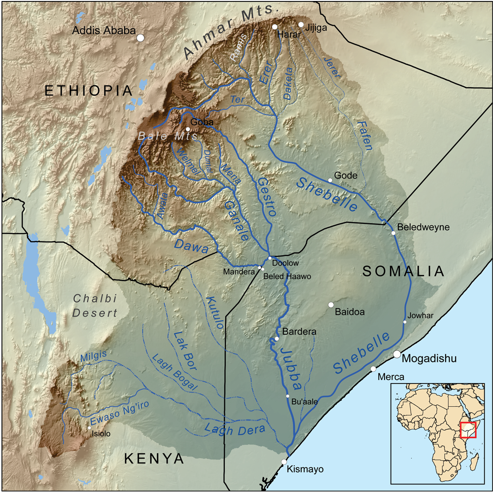
The Jubba river is 1004 km long and 122.5m wide. It begins in Doolow where the 3 Ethiopian rivers; the Genale, the Dawa and the Gestro have connected, and ends in the coast near Kismayo.
The Shabelle river is 1100km long and 83m wide and does not end in the Indian Ocean. Its originates from the Ethiopian part of the Shabelle river and the Fafen (which only joins in the rainy season).
As the Jubba and Shabelle rivers flow downstream through Somalia, the water flow decreases (SWALIM). This is caused by various factors including:
- The limited contribution of tributaries (streams) from the Somali catchment areas,
- Spillage of flood water into the flood plains (area around river which easily floods),
- Natural and manmade flood relief channels,
- River diversions for irrigation during both low and high flow periods, and
- Natural losses such as evaporation and infiltration/recharge of groundwater along the rivers.
The Jubba and Shabelle rivers in Southern Somalia are also prone to flooding. The Ethiopian highlands receive heavier and more frequent rainfall than Somalia, causing water to accumulate and flow downstream into the Jubba and Shabelle rivers, leading to flooding in Southern Somalia (SWALIM). The overbank spills of the rivers causes flooding in low-lying areas.
Most of the population in Southern Somalia live near the rivers, upon which they are highly dependent but the settlements are also prone to flooding. Flood management is thus essential for Somalia.
The Ethiopian dams and the rivers of Somalia
Ethiopia has invested billions of dollars into hydroelectric power from dams, due to their elevated location and abundant water resources. If they fill up these dams too fast however, there will be catastrophic losses for the neighboring countries, which is currently sparking a lot of debate concerning the Nile river.
Currently Ethiopia has many dams. One of those is the “Genale Dawa III Dam” in the Genale river and drains in the Jubba river. It was inaugurated and connected to Ethiopia’s grid in february 2020 (source). Backed financially by Chinese banks, the dam has has a capacity of 254 MW. The dam’s main aim was hydroelectric power and flood control. A concern was hereby raised; Does the Genale Dawa 3 dam pose a threat to Somalia’s rivers? This was analyzed in this article by Jamhuriyadda in 2018 by the Somali Engineers, Hussein Amiin and Guled (Wiliq) Ahmed both of whom have over a decade of experience in this field. Two points stood out to me upon further reading:
1) Ethiopia has a the right to use their resources to benefit the population, but they also bear the responsibility of the consequences to their neighboring countries when tampering with the nature:
- There is an urgent need for transboundary coordination between Ethiopia and Somalia to ensure the water balance and prevent any adverse impacts on Somalia’s reliance on the Jubba river.
- Ethiopia and Somalia have both signed the African Convention on the Protection of Nature and Natural Resources (1968). As per the convention, the two countries are required to coordinate their planning and development of water resource projects. It encourages the establishment of inter-state commissions to study and resolve any problems that may arise from the joint use of these resources.
2) Less water is flowing through the Jubba
- It is almost exclusively the Genale (>50% of the flow) and Dawa rivers that feed the Jubba river.
- A reduction in river flow of over 35% since the Dam was built has been reported.
Another 2 dams (Genale Dawa 5 and 6) are planned – a unilateral decision by Ethiopia, thus breaching the agreement in the African Convention on the Protection of Nature and Natural Resources.
With this comes the questions:
- What has been the precise effects of the Genale Dawa III Dam on the Jubba river so far?
- Did the the dam already contribute the the recent drought in Somalia?
- The dam was built for flood control, so will Ethiopia release the water during flooding and thereby flood downstream places instead? And will they keep holding on to the water during drought seasons, thereby worsening the drought downstream?
- How will Somalia’s drought and floods look in the future? Will Ethiopia be able to influence them?
Not many are currently addressing these questions, and fewer are coming up with solutions. However there is a website called shabelleriver.org, which has multiple reports describing the floods and both short-term and long-term solutions.
The answer to these questions lies in the data – however I do not have the skillset to confidently dive into it at the moment.
Bangladesh’s success with flood management
Back in November 1970, the world’s biggest and deadliest cyclone in recorded history hit Bangladesh – cyclone Bhola. 250.000-500.000 people were killed. Bangladesh lays low above the sea level and has a very high population density – which means cyclones caused floods that used to be very dangerous. But not anymore due to decades of active preparation:
The new efforts are:
- Predicting cyclones before they hit the country (early warning):
- Weather stations and forecastings systems using satellites – where they can predict the path of cyclones days in advance
- Better infrastructure 42 -> 12000 cyclone shelters since 1970, with room for more than 5 mio people.
- Women working and studying
- In 1991, an exceptional amount of 100.000 people died once again. This was due to many of the women not being in contact with the outside world – as they were at home. Today women are more connected through work and studying.
This has worked well. In the last 3 cyclones less than 200 people have died even though the population has doubled since 1970 – and the trend is clear: Less and less people are dying. Early warning systems are apparently very important. It was kinda there in the German flood which killed 200 people, but they weren’t taken seriously.
Even though Somalia probably doesn’t need to build flooding shelters, early warning and more connectivity is essential in the river-adjacent communities.
SWALIM is monitoring floods in Somalia
The Somali Water and Land Information Management (SWALIM) has a lot of data on ‘everything water’ in Somalia (including groundwater as I wrote about in the previous post). Basically it is a team under the Food and Agriculture organization (FAO) of the UN, working closely together with the government of Somalia. They have different units Somalia but the team is located in Kenya. I talked with Michael Makokha, a geographic information systems expert, who is involved in the development of the different tools SWALIM uses. Here’s some of the impressive projects they are working on:
Flood management system – SWALIM
They have created a Flood Risk and Response Information Management System (FRRIMS) tool for the Jubba and Shabelle rivers here: FRRMIS. Tools like this are VERY important, since they can help reduce the impact of flooding. They have access to very high resolution satellite data, whereby they can monitor the rainfall in Ethiopian highlands. Based on this combined with other measurement they are able to predict whether flooding is about to occur downstream in the Somali villages. Hereafter disaster charters are activated (link here) and warnings are sent to the locals via SMS, so they are prepared.
Below are a few screenshots of their flood monitoring tool so you can see how it would look. The first one is their data on the flood levels – here for Bardheere which were experiencing flooding.
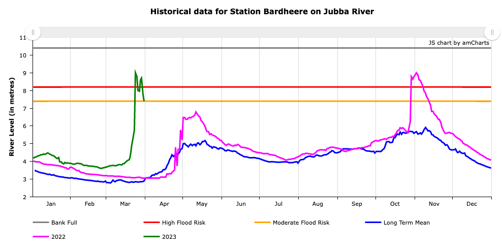
The figure shows the flood station at Bardheere – one of seven placed by SWALIM along the Jubba and Shabelle rivers. The green line is the current levels. For the last 10 days (end of green line), it has showed there is a flood risk. The other stations upstream has shown a similar trend – from around march 19 there was a huge spike.
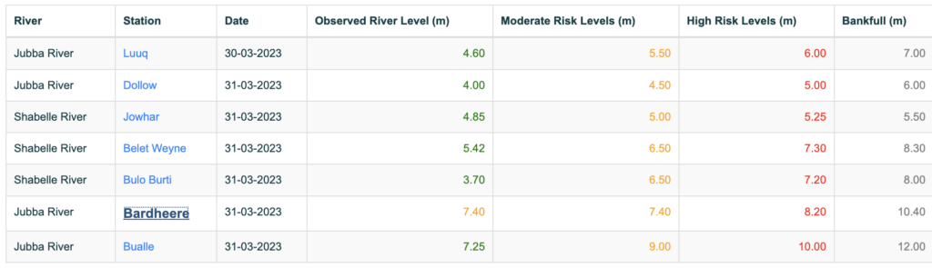
All 7 stations are placed along the 2 rivers, and their levels can be seen in these two images. The data is shows the river levels. They have locals going out and documenting the measurements manually every day.
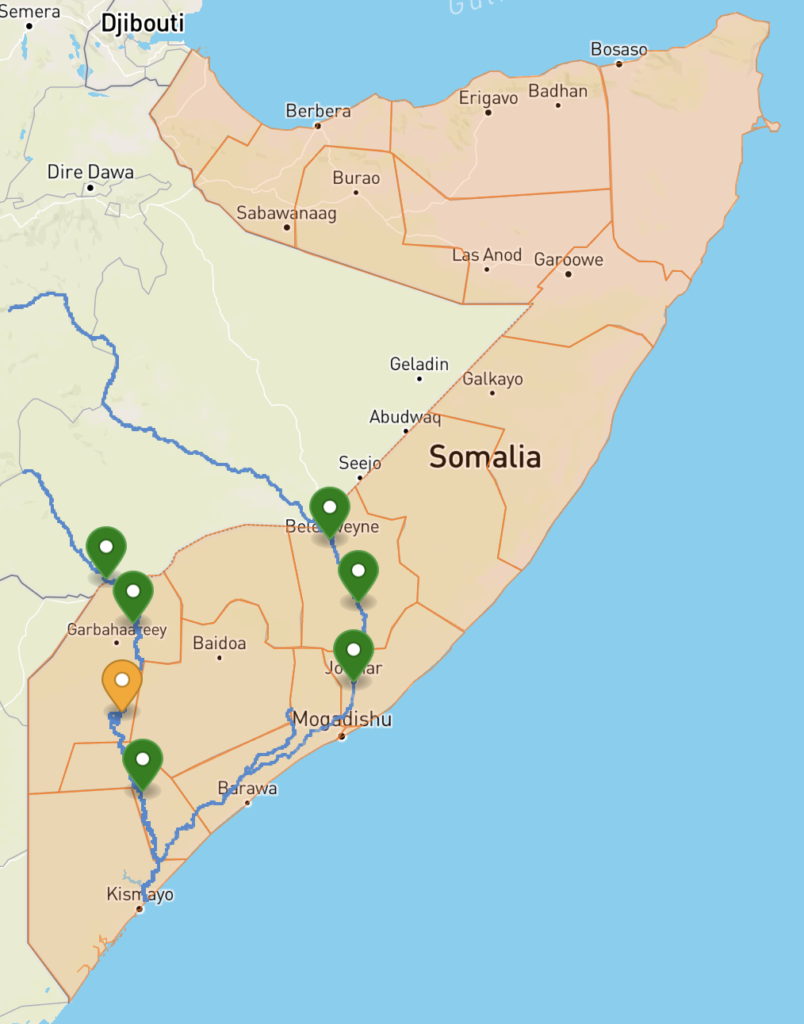
River Breakages – SWALIM
SWALIM has also mapped all the river breakages along the Jubba and Shabelle river. These are places where breaks or openings in the river embankments have occured due to natural causes such as floods or erosion, or more likely due to human activities such as construction or agricultural practices (canal irrigation). Thus, they are not supposed to be there. They use very high resolution images to track these river breakages, but it is still difficult to know their exact causes.
The breakages can cause water to overflow or divert from its usual course, leading to flooding and other related hazards. Identifying and repairing river breakages is crucial for maintaining the integrity of river systems and mitigating the impacts of floods. They monitor all the river breakages and give them statuses such as “open”, “potential” or “closed with sandbags” source. I was told they repair the breakages 2 times a year in the dry seasons – usually february and August. SWALIM has made guides for making sandbags to close the open river banks and what to do/not do during and after flooding: link. Sandbags are not the best, however, so closing the breakages with machines is much better.
Illegal openings on river embankments, which are created to allow for irrigation water during the dry season, worsen flooding by allowing water to escape during high river flows, causing damage to nearby land. There are currently 36 river breakages on the Shabelle River and 26 on the Jubba River, requiring immediate attention!
Lastly, SWALIM is not slowing down. They are e.g. currently working on a river flow measurement tool, which can measure the rate of the river flows and not just the heights. They haven’t been able to do it before due to the concurrent security threats in southern Somalia. They are building dams in the North of Somalia, as part of their “integrated watershed management” where they want to capture water from runoff in a dam. This can be used for livestock and irrigation.
Smart solutions to the floods
1 year ago, the UN conducted a study called “Sustainable Flood Management and Risk Reduction Action”. The study is summarized in this article. It is a part of a larger project from Somalia’s Ministry of Energy and Water Resources. Here are the key points from it:
1st, they show how vulnerable cities, such as Beledweyne, near the rivers are to floods – this we already know.
2nd, they point out something very cruical. They identified that water storage and effective management of water extremes are crucial factors for the development and food security of Somalia. We will dive into this in the next post! 🙂
3rd, and most importantly: Their study suggests that V-shaped or V-notch weirs (low dams) and planting shrubs, grasses, or trees can mitigate the impact of flash floods in Somalia. Dams impound water, while weirs change river flow characteristics, recharge groundwater, and store water for later use. The combination of V-shaped or combined weirs can reduce flood peaks, which can minimize downstream losses in settlements. This is a relatively straightforward solution.
4th, they also found other effective ways, e.g. terracing (basically stair-like farms) and diversion. Terracing: Constructing terraces along contours in the catchment area (i guess they mean the Ethiopian or Somali highlands) can reduce loss of soil loss from erosion of the top layers. Apparently there is more control of where the water is going through terracing and it can keep the soil intact better.
Diversion: Diverting excess water to areas where flooding will cause minimal damage can also be achieved through the use of downstream structures.
5th, they dive into early warning approaches, which is actually crucial, but not really the focus of this post.
Flood management in Somalia – Nothing new:
The management of water resources in Somalia’s Jubba and Shabelle Rivers involves the management of floods and provision of irrigation water.
In the past, traditional customs determined the right to access water, but during the former Somali government, laws regulated water management (e.g. Natural Water Resources Law of 1984 regulating access and use of the Jubba River waters). They even had systems for floods and irrigation management e.g. in Jowhar:
In 1980, the Jowhar Offstream Storage Reservoir (JOSSR) was constructed in the Shabelle to collect excess river flow during the wet season and provide irrigation water during the subsequent dry season, while also serving as a flood relief channel if necessary (Houghton-Carr, 2011). It could hold 200 million m3 of water. During times when the river had low water levels, the water that had been diverted to the JOSSR would be redirected back to the river, thus supplying essential irrigation water downstream and helping to reduce the frequency of drought during that period.
The progress achieved in managing flood and irrigation water was lost when the Somali government collapsed. The institutions responsible for the management were unable to operate, and the flood and irrigation infrastructure that had been put in place deteriorated due to lack of maintenance and vandalism. This led to recurrent flooding in the riverine regions of Jubba and Shabelle, causing significant economic damage.
The JOSSR seems like a great solution to Somalia’s flooding and drought problems at once. It needs to be brought back, and SWALIM is apparently working on that.
In the past 20 years, numerous humanitarian and development organizations have been working to rehabilitate the deteriorated water systems in Somalia. SWALIM is involved in the rehabilitation process by offering information to partners involved in designing intervention programs in Somalia.
In 2018, Somalia and Turkey signed an agreement to rebuild the JOSSR (Hiiraan news)!
Same year, Hirshabelle state planned to build dams along the river to avoid the expensive consequences of flooding.
A personal take:
As I am finishing up this article, at the end of April 2023, floods are hitting Beledweyne once again, and the water levels on SWALIM’s tool are also too high. The floods are not going away – they will keep coming as they always have and probably with more intensity and frequency due to global warming. In addition, Somalia needs better communication with Ethiopia, since both the important rivers have their main catchment areas there, and everything that happens there will affect the downstream water in Somalia.
There’s also gotta be more control along the rivers, as there were in the 80s. Currently there is an open river breakage in Luuq, a site where a flood has recently originated <1 year ago. As we have entered the Gu rainy season, this seems dangerous and should be closed.
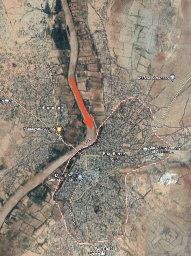
Personally, the solutions I see is for the population to move further away from the rivers. If you look at google maps, you will see Bardheere is way too close and downstream of a turn in the Jubba river.
If they insist on living so close to the rivers, another suggestion would be to raise their houses like they do in many parts of the world. These “flood-proof” houses could be on stilts. This is not the cheapest of solutions either.
Another thought is digging artificial empty rivers along e.g. the Jubba river, and then place gates along the it that can open and fill up the artificial rivers up in the event of floodings. Sort of like a “relief river“.
I do acknowledge that these solutions might seem smart, but they have not been worth exploring for a large part of the population due to the risk of Al-Shabaab taking everything they own. It has simply not been worth it. However times are changing, and the thread is decreasing, and with that – it’s time to think about the solutions. Last year, the “Integrated Water Resources Management” master’s program was created in Somali National University – hopefully these graduates will help solve the long list of issues regarding the waters in Somalia. The president, Hassan Sheikh Mohamud, has also pointed out, that we need to be better prepared for disasters rather than responsive afterwards. Flooding and drought catastrophes cost billions of USD in aid, but education, preparation and prevention strategies costs less and should be prioritized.
More sources
- Great article on “Jamhuriyadda” from 2019: https://jamhuriyadda.com/2019/11/13/devestating-floods-impact-beled-weyne-again/
- SWALIM report from 2009: “Support to the Sustainable Management of the Shebelle and Juba Rivers in Southern Somalia”
- SWALIM report from 2007: “Improving Flood Forecasting and Early Warning in Somalia“

[…] Rainfall determines droughts and floods in Somalia – we covered both in our drought article here and flood article here. […]
[…] off-stream reservoir: In our floods article we described The Jowhar Offstream Storage Reservoir (JOSSR). It’s actually a really cool and […]