
Beneath the dry lands of Somalia, there is an increasing amount of groundwater storage – enough to make the droughts from the previous post a thing of the past! Let’s explore it.
Groundwater found in Somalia
Take a look at this (I will summarize the main points below):
Most countries in Africa have enough groundwater supply for more than 50 years. And even more interesting, the supply is actually increasing due to the intense rainfalls in recent years whereby the rain easier infiltrates the soil! This means Somalia is sitting on a huge untapped potential of underground water which could be used for food, drinking, agriculture, livestock and much more. The World Bank and the private sector are already exploring this and has begun groundwater drilling. The water resides only a few km below the surface, and can be reached in weeks.
Next, there is an interview with professor Michael Singer from Cardiff University were he is talking about the new research.
Groundwater hasn’t really been utilized in Somalia, as it requires a heavy investment which hasn’t happened compared to India. Only smaller wells have been dug, to access the groundwater. Additionally, after heavy rainfall, the underground water is only a few meters below the river channels, which the rural populations often use, he explains.
Before diving into the research paper, I will take you on a detour through groundwater in general and how to use it. If you cannot wait, you can click here to scroll directly down to the research paper
How Libya tapped into its groundwater
Libya is a North African country with a desert climate, where freshwater resources are scarce. 90% of the country is covered by desert, and there is very little rain, which evaporates quickly when it falls. The country’s solution to tackling its freshwater deficit has been to tap into its vast underground water resources.
The Nubian Sandstone Aquifer System is the world’s largest known aquifer system with an estimated 150,000 km3 of groundwater. It is located in South-East of Libya (34% of it) in addition to Egypt, Sudan and Chad. This means, that Libya’s underground water system is one of the largest in the world.
To access these underground water resources, Libya has invested heavily in developing a vast network of pipelines and pumps. The Great Man-Made River Project, launched in the 1980s by Libyan leader Muammar Gaddafi, is one of the most ambitious infrastructure projects in the world, designed to bring freshwater from under the ground in southern desert regions to the densely populated coastal areas.
The project involved drilling thousands of wells into the country’s underground aquifers and pipelines that stretch for over 4,000 kilometers. The water is then distributed to the north of the country where households and businesses are mostly located.
The Great Man-Made River Project has been instrumental in providing freshwater to the Libyan population and supporting the country’s agriculture and industry sectors. The project has also helped to reduce the reliance on rainfall and surface water resources, which are scarce in the desert regions.
However, the project has not been without its challenges. The drilling of wells and the extraction of water from underground aquifers have led to a decline in groundwater levels and the drying up of some wells. There are also concerns about the sustainability of the project, as it relies heavily on fossil water that is not replenished at a rate that matches the extraction rate.
As groundwater has been discovered in Somalia, could we do the same?
Could the supply of underground water help us deal with the expensive and deadly droughts, that are happening with increasing frequency in the country, making economic progress very difficult?
What is groundwater anyway?
Let’s dive into hydrology for a little.
70% of the Earth is covered by water and 97% of all the water on earth is saltwater in oceans (aka seawater) while the remaining 3% is freshwater. Of that 3% freshwater, ca. 70% is stored as ice, glaciers (e.g. in antarctica), while only 30% is groundwater and surface water usable for drinking. So despite having all this water on earth, we only have access to a little part, and should be mindful of how we use it.

The water we drink today, is the same water that was drunk millions of years ago, and this is due to the water cycle.
The water cycle
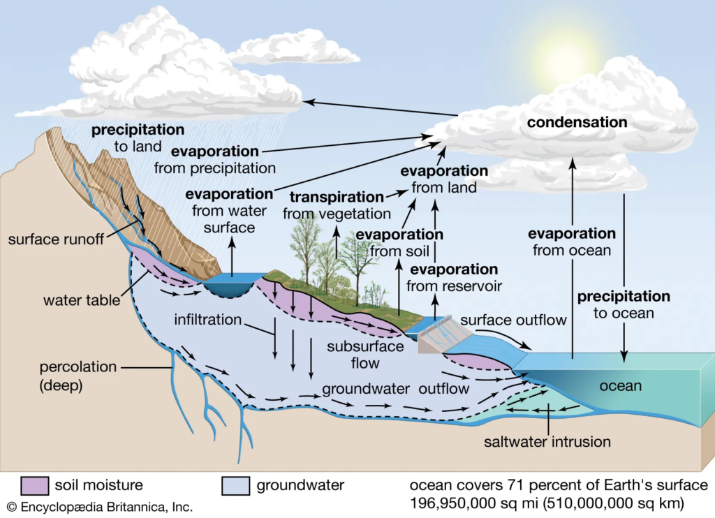
Evaporated water rises towards the sky and condenses into clouds and fog. Condensation is when water vapor in the air is changed into liquid water droplets – this is illustrated in the top-right of the figure. Follow the cloud towards the left, the condensed water in the atmosphere falls to the ground through precipitation as rain (or snow), where it becomes runoff. Runoff is when the water hits the ground and becomes a lake, river, or stream. This is all surface water. If the precipitation infiltrates the ground, it becomes groundwater.
These are the two different sources of drinking-water supply.
Runoff picks up everything (biological and non-biological contaminants) on the surface towards the lake, river or stream. However for groundwater, the earth will filter out surface contaminants as it seeps through the ground – but, the water will also pick up the contaminants the earth is made-up of which contributes to its mineral content. So the source of drinking water will be characterized by the surrounding environment.
Evaporation is when the sun hits water from lakes, rivers, streams, or oceans which evaporates into the atmosphere – here water goes from a liquid phase to gas phases. Transpiration is basically evaporation but from plants.
Groundwater and Aquifers
When dealing with groundwater, you will run into the term “Aquifer” a lot, which is just underground structures where water is stored. There are two types: 1) An unconfined type, and 2) a confined type.
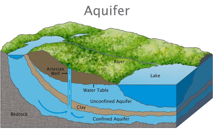
Groundwater: The water contained in the interconnected pores underground in aquifers
Aquifer: An aquifer is an underground layer of permeable rock, sand or gravel that can store and supply water. It can be tapped by wells to provide water for various uses. It’s pronounced “a-kwuh-fer”.
- Confined groundwater: Also known as artesian groundwater, it is found in a saturated zone under pressure and is separated from the surface by an impermeable layer such as clay or shale, that prevents water from seeping into the aquifer from the surface.
- Unconfined Aquifer: A type of aquifer that is not overlain by an impermeable layer. The water in an unconfined aquifer is therefore directly exposed to the atmosphere and can fluctuate in response to changes in precipitation. It is a layer of permeable rock or sediment that contains groundwater that can be extracted through a well.
- A water table is the upper surface of an unconfined aquifer. The water table represents the boundary between the unsaturated zone, where the pores in the soil or rock are filled with air and/or water, and the below saturated zone, where all the pores are filled with water.
Subsidence: Sinking. When an aquifer is over-pumped, and the ground starts sinking to fill in the void.
Literally ground-breaking research
Let’s dive a little into this research and see what they actually found in the research article below.
Here is the short version:
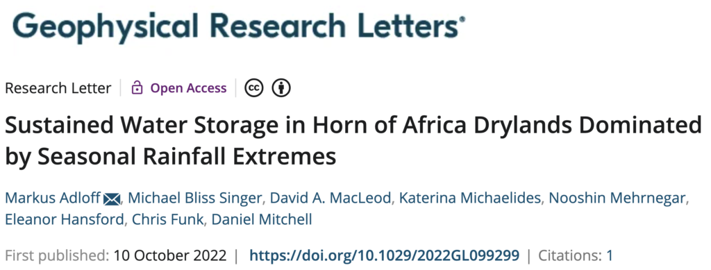
In a recent publication, researchers from Cardiff University in Scotland used satellite data and found that the underground water storage in the Horn of Africa is actually increasing. Despite an overall decrease in rainfall in the region, they saw an increase in the “high-intensity” aka “extreme” rainfall events, the type that seeps to the underground water storage, during the October-November-December rainy season.
So the correlation is between the extreme rainfall and underground water storage/reserve.
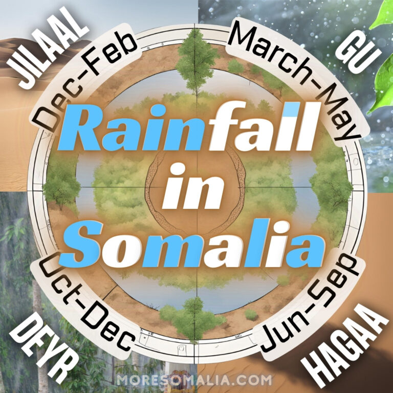
Rainfall in Somalia
Groundwater storage in Somalia
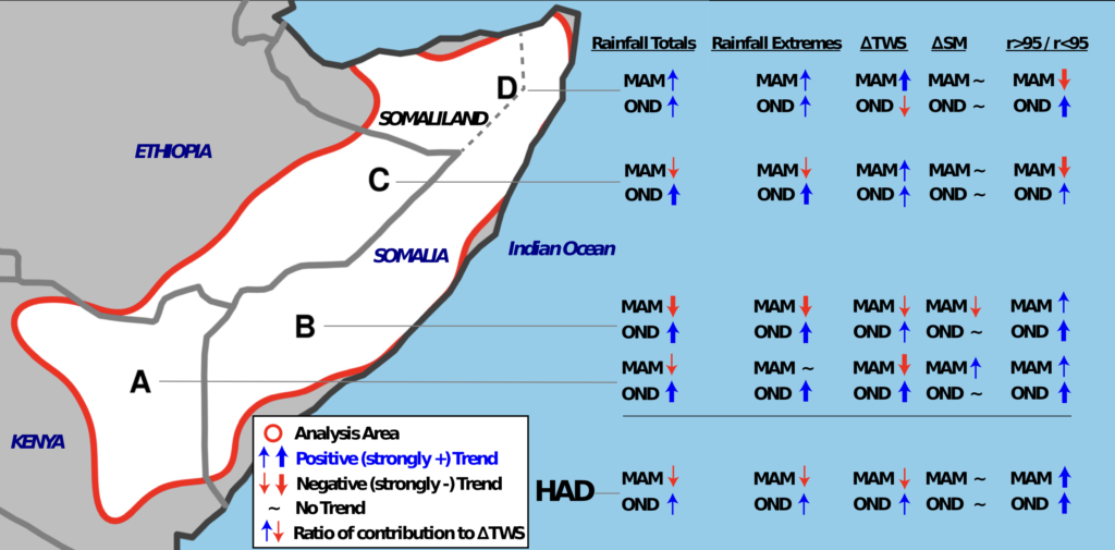
So to summarize, the increase in underground water storage in Somalia is all because during extreme rainfall, the water seeps into the ground below the zone of evaporation – either deep into the soil or from dryland to river channels into the riverbeds and then into the ground.
Attempting to look for groundwater using satellite data
This is very interesting, so to satisfy my curiosity, I tried exploring public rainfall data and satellite data to check the results from the article above. I should start by saying, I am by no means an expert on this subject. So here are a few illustrations of what I found.
Task no. 1: Rainwater
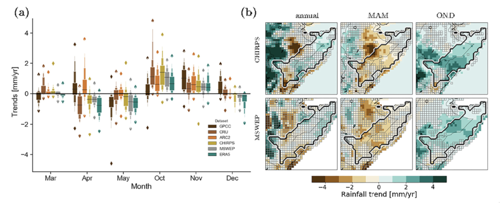
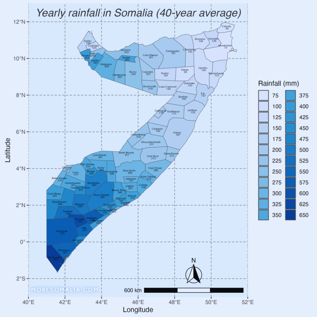
First, let’s start with rainfall in Somalia like they did in the article above. So how much does it actually rain in Somalia? I found the rainfall data from CHIRPS, and started analyzing and plotting away in R. As expected, the more south or west you go in Somalia, the more rainfall you will see. The Bari region experiences the least rainfall in Somalia.
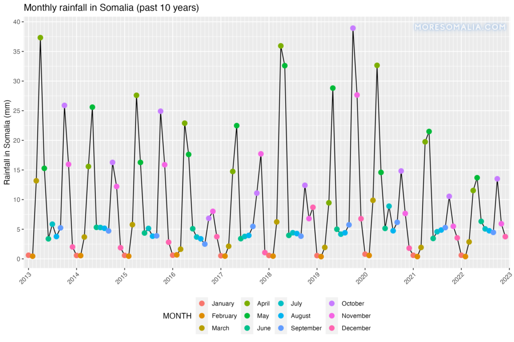
As explained in the previous post about drought, we have 2 rainy seasons in Somalia. Below you can see, how much rain falls in each month in Somalia. It is clear, that throughout the country, most rainfall happens in April/May during the long rains and then in October during the short rains. And take a look at how little rain fell last year in 2022 – the March-May (MAM) rainy season was reported to be the driest in 70 years!
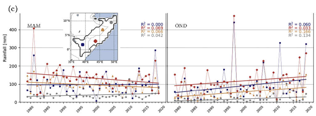
In the article, they found that the MAM rainfall decreased, whereas the OND rainfall later in the year actually increased. I have plotted both 10 (above) and 40 years (1983-2023) of available rainfall data for the entire country. So what does this data show? The blue line shows an average trend rainfall during each of the rainy seasons. What we can see is that rainfall has a lot of variability, and a straight line showing the average (which I must admit I made first) does not tell us too much. For MAM, we did see a decrease untill 2004, whereafter rainfall was increasing until the drought of 2016. Since then it has been falling. Regarding the OND, there was an increase in rainfall until ca 2000, and since then it hasn’t changed much.
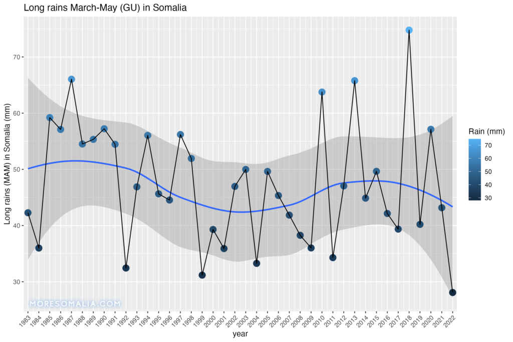
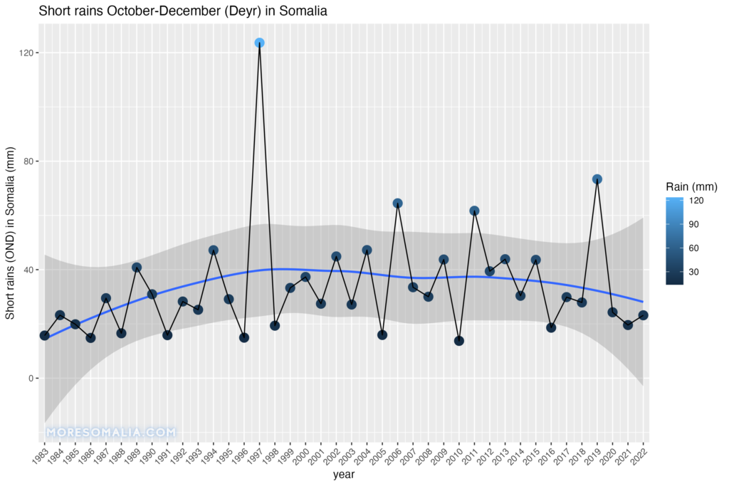
The big spike you see is the Jubba Valley flooding of 1997. Original graph made in R.
Task no. 2: Underground water
So, if you look into the article, you can see they are using data from the GRACE satellites to measure the changes in groundwater. Fortunately, all the data is open and accessible to all.
The Grace satellites are a pair (called Tom and Jerry) that orbits the earth ca. 200 km apart from each other. They measure changes in the earth’s gravity field and thereby indirectly the changes in the groundwater storage, because changes in the mass of water stored underground (e.g. after extreme rainfall) leads to changes in gravity field.
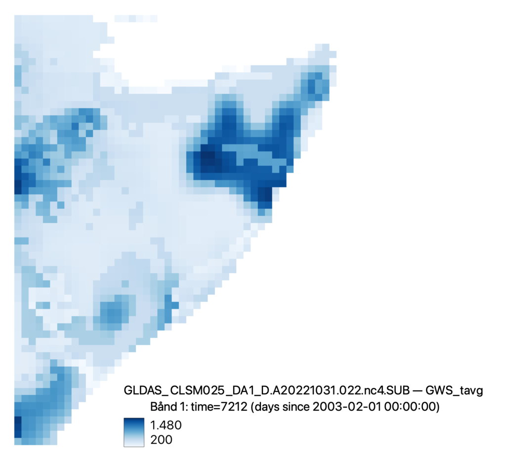
First, I downloaded all the daily measurements from 2003 to 2022 from GLDAS. After a lot of struggles, I finally got the 7000 “.nc” files. I then tried plotting them, 1st in R which took way too long, and then in QGIS which gave me this pixelated but great map.
I then found the GIOVANNI service by NASA which is a website to access, analyze and visualize the same data without having to download it all – much easier and faster. I picked the october-december months in the years 2006, 2011, 2016, and 2021 illustrated in chronological order below. This is what I got:
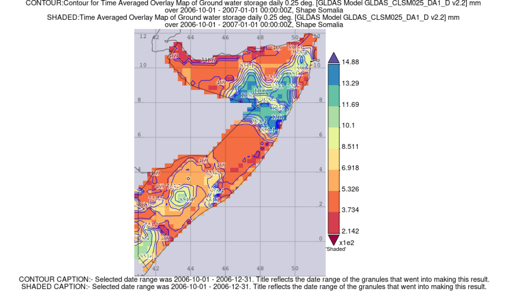
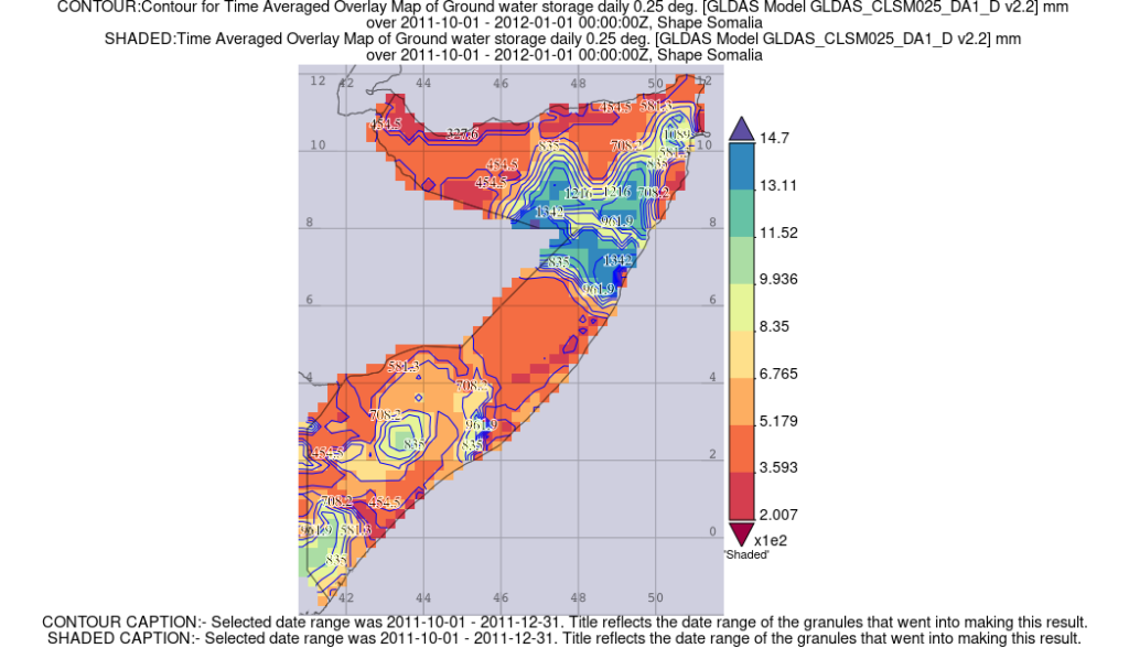
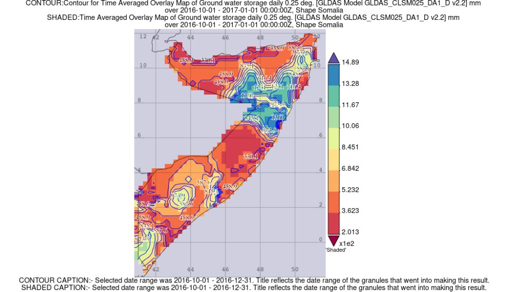
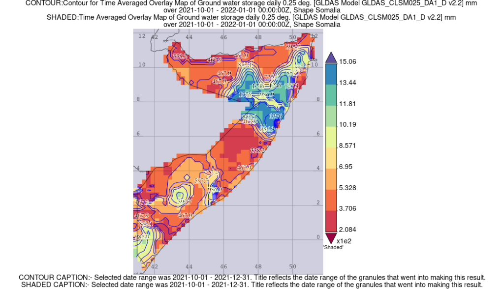
The maps shows the ‘time-averaged groundwater storage in millimeters’ for each day in the selected 3 months. The original data was generated using a GLDAS (Global Land Data Assimilation System) model. Fortunately, the groundwater data from GIOVANNI and QGIS basically show the same, which makes sense since both are using the GLDAS model. The GIOVANNI map provides an overview of the amount of groundwater stored in the soil and underlying aquifers across a large geographic region.
The colors on the map represent the range of groundwater storage values – blue indicating areas of high storage and red indicating areas of low storage, which is also shown in legend to the right of the map.
By examining the map, it is possible to identify patterns and trends in groundwater storage over time. For example, areas of high groundwater storage may correspond to regions with high precipitation or permeable soils, while areas of low storage may indicate regions with low precipitation or high rates of water withdrawal. Guessing from these maps, it might seem like most of it is stored in the Nugaal region – and the most blue region is near Eyl.
But remember, GRACE data does not show us the ground water storage directly – it just measures water mass variations to a specific depth. It must be combined with other tools and validated by physical exploration of the groundwater. To determine actual water availability, depth, and drinkability in places like Nugal, one must delve into parameterization, approximations, error assessments of Grace data, in addition to cross-reference findings with alternative methods like drilling, groundwater modeling, and water quality testing. When we begin to drill for groundwater these data can provide important information for managing water resources, identifying areas of overuse or depletion, and how to manage the groundwater.
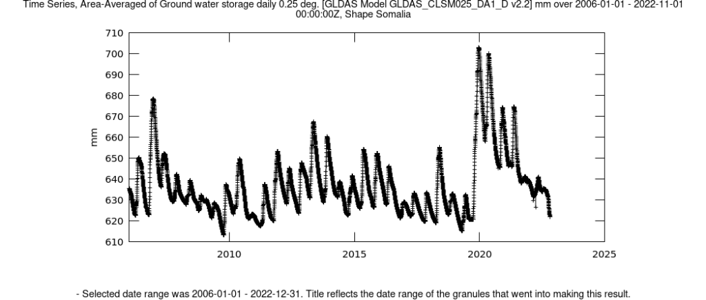
The graph above shows a time series of average groundwater storage between January 1, 2006 to November 1, 2022 for all of Somalia. The graph shows information about the long-term trends in groundwater storage in Somalia. Surprisingly, we can see a huge peak at the end of 2019, which is during the flood of 2019 in Somalia. Since then we have entered the current multi-year drought.
Who’s looking into groundwater?
SWALIM
When it comes to data on the climate in Somalia, you should know about SWALIM (Somali Water and Land Information Management). It is a fantastic project, which is providing a lot of on-the-ground data in Somalia in addition to recovering much of the data lost to the civil war. On their website it states their mission is “To Empower The People Of Somalia To Preserve, Manage And Protect The Vital Natural Resources Of Land And Water Within Their Territories To Improve The Lives And Livelihoods Of All Somalis In This And In Future Generations“. Technically managed by the UN’s FAO institution, they work with different somali institutions to achieve self-sufficiency in their capacity to generate and manage natural resources information.
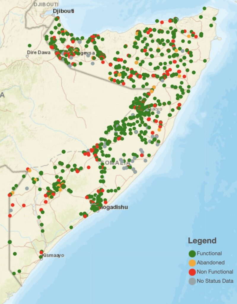
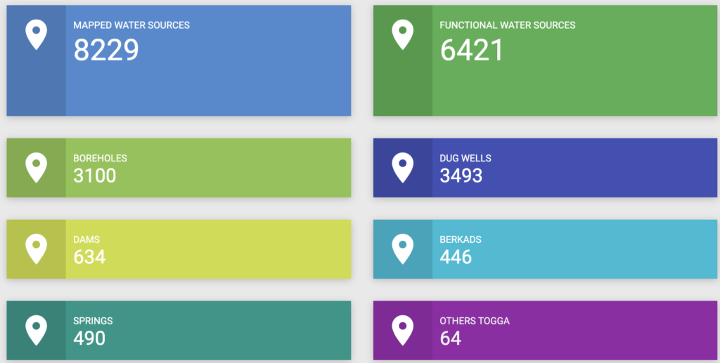
One of their focus points is groundwater in Somalia, where they have mapped every single water well they have been able to, as you can see in the map below. In East Africa, due to the dry weather, groundwater is the primary source of water. In Somalia, groundwater extraction is typically confined to subsurface aquifers that are only 10s to a few 100s of meters deep.
Ruden AS
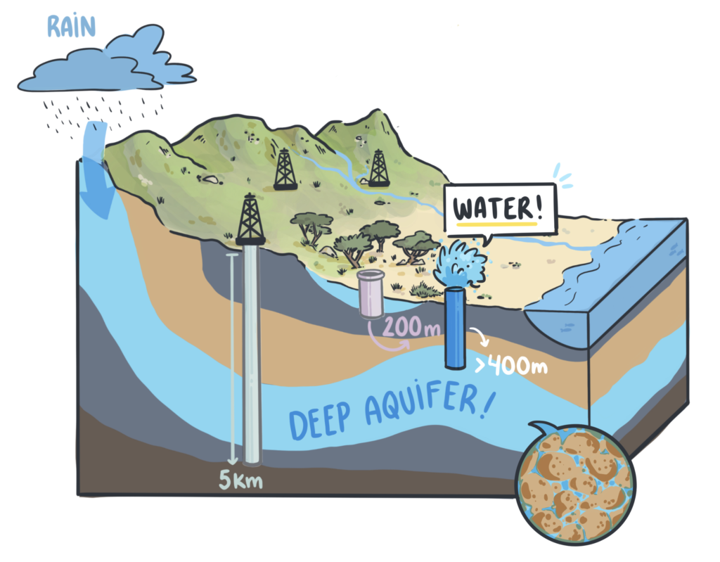
A Norwegian company called Ruden AS is currently running a project called “Somalia Deep-Groundwater project” which started in 2019. Funded by the Norwegian ministry of Foreign Affairs they are assessing the national potential for deep underground water as a resource. They want to involve the Somali diaspora, and last year hosted an event with the Norwegian “Somali Norwegian Strategic Partners (SNSP)”. The Ruden AS company already have decades of experience in digging for deep aquifers >400 meters in Africa. They are of course also in talks with SWALIM.
“There is a huge potential for deep groundwater in the Somali peninsula. Deep aquifers within Somalia are recharged in the Ethiopian mountains and find there way to the Indian ocean over 10s and 100s of years. If utilized sustainably, deep groundwater can solve both current and future problems related to water scarcity”
Ruden AS
So how are they identifying the groundwater sources? By using already existing data from the oil and gas industry. The data is seismic lines (e.g. using audio waves) and well logs (e.g. borehole wells and measuring tools), and can tell us about the structure of the earth deep below the surface.
Aquifers have many similarities with underground oil reserves, so the data which the oil and gas industry has spend a lot of money on and used to map the ground under the surface of Somalia, can also be used to find underground water reserves – and this is where Ruden AS is pioneering.
Ruden AS is all about going deep. And their method is working.
Using old oil exploration data in 2005-2014, they were able to explore and discover a submarine aquifer in Tanzania called the Kimbiji aquifer. This aquifer is 1000 m deep and contains around 5000 km3 of freshwater, which is sufficient to support a population of 1 million people for up to 3000 years. The aquifer was discovered by Ruden AS through the drilling of three exploration wells, whereafter the company CDM Smith collaborated with Ruden AS to drill an additional seven wells to fully determine the aquifer’s potential. Afterwards, the field was transferred to the local authorities for further development. And now they are using a similar approach to discover underground water in Somalia, since the ground structure is similar.
In a recent research paper by Ruden AS, they present new evidence of the existence of deep aquifer systems in the Horn of Africa. They created a 3D subsurface model that can predict different characteristics such as probable thickness and salt content of the potential aquifers.
The geological structures that the water has travelled through, and is contained in, under the ground is important because affects its mineral content and taste. The geology of Somalia is diverse, and although we will not dive into it in this post, it does indeed play a role when it comes to borehole drilling.
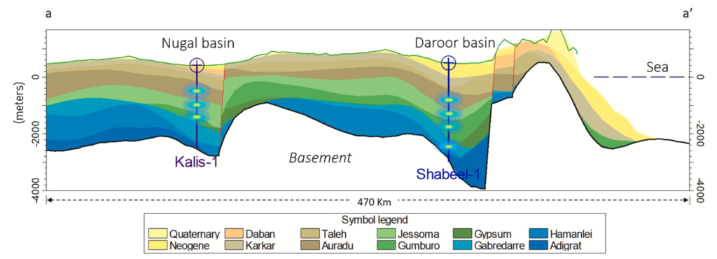
The outcomes provide valuable knowledge about potential aquifers. E.g. they find that the so called Adigrat, Hamanlei, Gabredarre, Gumburo, Jessoma, and Auradu (limestone) ‘hydrostratigraphic units’ has significant aquifer potential across the region. Although not very deep, the Jessoma and Auradu units exhibit consistent and favorable aquifer characteristics, with high values of permeability and porosity and both also seems to have the lowest salt content. After more specific surveys, these aquifers can be exploited in a safe and sustainable manner for the population.
From their website, we can see they are cooperating with the federal government of Somalia to establish a team led by Somalis that can work towards this long-term solution. That’s why they will soon engage in training programmes and making their data public, so the locals can fully take advantage of it.
The current wells in Somalia are usually less than 400 meters deep. But further down, there seems to be better water-sources which requires money, resources, and technological expertise to find and extract. Despite this, the oil and gas industry have managed to dig at least 80 wells in Somalia, multiple km into the ground in some areas with freshwater – and it is this data Ruden AS is currently using as part of their ground water exploration in Somalia.
With aquifers in Somalia containing over 10 quadrillion liters of water already stored underground + a constant recharge of 12 trillion liters per year, the research shows this is a hidden gem that can supply the entire region multiple times with fresh drinking water.
The first phase is data interpretation, which will be completed in May 2023. Hopefully, the next phase after this is the drilling of exploratory wells to get some current physical data from potential sites for extraction of groundwater.
World Vision Water
World Vision is a humanitarian organization, who focuses on world poverty and especially children. A great visual storymap was created regarding their work with underground water in Somalia: Access it here. They too are working with SWALIM.
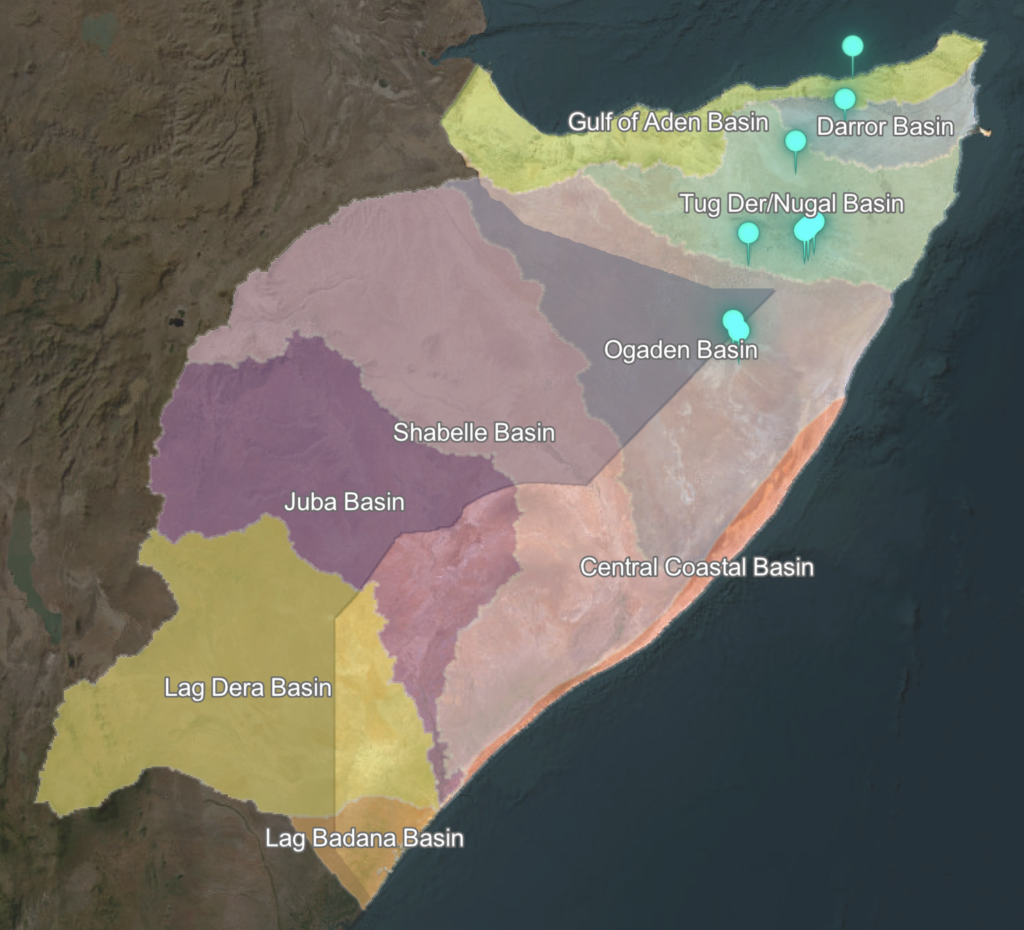
Somalia has nine river basins as its principal hydrological boundaries (see the map below). However, only two of these basins, 1) Shabelle Basin and 2) Juba Basin have rivers that flow throughout the year.
In contrast, due to the arid (another word for desert) and semi-arid climate of northern Somalia, basins such as 3) Ogaden, 4) Tug Der/Nugal, and 5) Darror (the location of groundwater sensors) have no year-round surface flow. In addition to these we have the 6) Gulf of Aden Basin (covering the entire northern coast), 7) Central Coastal Basin (following the coast from Kismayo, through Mogadishu, to a place called “Raas Cabaad”, 8) the Lag Dera Basin and lastly the 9) Lag Badana Basin.
The communities living in this sparsely vegetated and parched North depend almost entirely on groundwater resources. Therefore, it is essential to examine the underlying aquifers in northern Somalia more closely.
The Puntland region’s aquifer types all exhibit moderate to high groundwater yield.
As an example, they have the Ligle 2 Borehole near Garowe, and with a depth of 160 meters it is the highest yield borehole of the nine. Almost 30,000 people in the city rely on it as their primary source of clean water. Puntland State Agency for Water, Energy and Natural Resources (PSAWEN) are often involved in inspecting the different wells in that region.
World Vision Somalia collects groundwater data collected by the real-time sensors they lower into the well, and from here they could see the water level was decreasing, possibly due to the drought. One of the main challenges with these shallow boreholes is the salt content and they can run dry. Some of the deeper aquifers, contain much less salt in addition to not being affected by changes in the surface climate.
A tool to fight against droughts and rebuild Somalia
The 6th of the 17 UN “sustainable development” goals is providing safe water to all by 2030. In Somalia, a lot of people (especially pastoralists living of their livestock) are highly dependent on rainfall for water. These people are suffering the most during the increasing droughts (and floods). But Somalia has enough underground water to cover the needs of its population for at least 50 years – and this accounts for the rest of Africa as well.
We need to be careful though, as deep aquifers contain fossil water that is not renewed. Saudi Arabia managed to deplete 80% of its Arabian Aquifer System which is now the most over-stressed aquifer in the world. They saw a boom in agriculture and food production, but now they cannot keep it up and they are looking for help in other countries for their agriculture sector.
So although underground water solutions are not long term, they can kick-start a literal ground-up development, where the funding can go to progressive projects rather than disaster management. The technology and resources to transition into deep groundwater supply has been lacking in Somalia, but now multiple agencies are stepping in with their world-class expertise, collaborating with the local experts with the aim of transfering the know-how rather than exploiting it for themselves. If everything goes well, it will not be many years before deep aquifers are used in Somalia for water and the rest of the Horn of Africa. Good relations with neighboring countries is important to avoid a “Water Crisis”.
Coupled with other solutions such as desalination plants, reforestation, solar, wind energy, and increased agriculture, the Somali population can develop faster in a self-reliant and sustainable manner.
More Sources:
- https://www.deepgroundwater.no/
- FAOWALIM’s report: Hydrogeological Survey and Assessment of Selected Areas in Somaliland and Puntland
- https://www.youtube.com/watch?v=XOnz4EeA1Ic
- https://earthwise.bgs.ac.uk/index.php/Hydrogeology_of_Somalia
List of institutions I stumbled upon while researching groundwater in Somalia
- SWALIM
- FAO
- Ruden AS
- World Vision
- World Bank
- British Geological Survey – Data and background information
- Puntland State Agency for Water, Energy and Natural Resources (PSAWEN)

[…] The Somali Water and Land Information Management (SWALIM) has a lot of data on everything water in Somalia (including groundwater as I wrote about in the previous post). […]
[…] There will be better focus on growth. Currently the Somali government is going to invest a lot into deep groundwater. This is a great step in the right […]
[…] societies including Somalia, which has received a huge investment into this sector. The search for groundwater is […]
[…] in ground water: Our most popular article is about the deep groundwater projects in Somalia. Below the surface Somalia is sitting on enough […]